Best Asset Management Software for Local Governments
Compare Cartegraph, Cityworks, and CityReporter for municipal public works and GIS — map-first vs planning-first vs inspection/CMMS.


If you need the short answer: OpenGov is the best fit for many local governments that want one system for assets, work orders, GIS, and capital planning. Cityworks is the top pick for GIS-first teams. Cartegraph is strongest for long-range planning. Brightly fits facilities and parks. NEXGEN works well for utilities and public works. Catalis makes the most sense when finance and ERP links come first.
Local governments are under pressure. The average U.S. municipality faces a $3.5 million deferred maintenance backlog, and about 40% of municipal operating budgets goes to reactive repairs. So the right software choice usually comes down to three things:
- What assets you manage: roads, water, stormwater, parks, buildings, fleet, or all of them
- How much GIS you need: map-first work vs. lighter map support
- How far you need to plan ahead: daily work orders, condition scores, or multi-year budget forecasting
This guide compares six platforms:
- OpenGov Enterprise Asset Management
- Trimble Cityworks
- Cartegraph Asset Management
- Brightly Asset Essentials
- NEXGEN Public Works Asset Management
- Catalis Infrastructure and Asset Management
Here’s the simplest way I’d break them down:
- OpenGov: best all-around fit for many cities, counties, and districts
- Cityworks: best for teams that live in Esri ArcGIS
- Cartegraph: best for condition scoring and funding scenario planning
- Brightly: best for buildings, campuses, parks, and routine maintenance
- NEXGEN: best for utility-heavy public works teams
- Catalis: best for agencies that want asset data tied closely to finance, payroll, and citizen requests
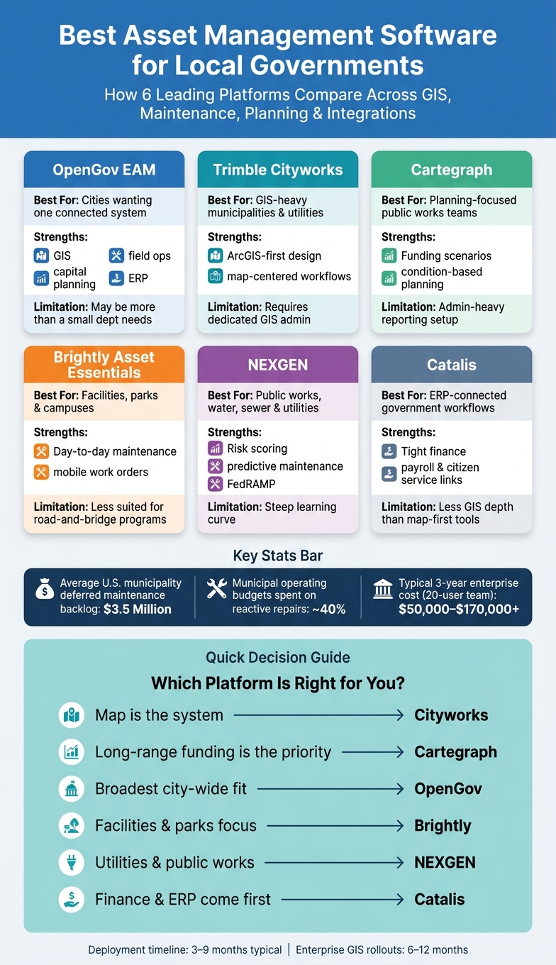
Best Asset Management Software for Local Governments: Side-by-Side Comparison
Cityworks AMS Introduction: Work Activities
sbb-itb-fd683fe
Quick Comparison
| Platform | Best For | Main Strength | Main Limitation |
|---|---|---|---|
| OpenGov EAM | Cities and agencies that want one connected system | Strong mix of GIS, field work, maintenance, and capital planning | Can be more system than a small department needs |
| Trimble Cityworks | GIS-heavy municipalities and utilities | ArcGIS-first design | Needs solid GIS admin and setup work |
| Cartegraph | Planning-focused public works teams | Funding scenarios and condition-based planning | Setup and reporting can take more admin work |
| Brightly Asset Essentials | Facilities, parks, and campuses | Day-to-day maintenance and mobile work orders | Less suited for road-and-bridge programs |
| NEXGEN | Public works, water, sewer, and treatment teams | Utility-focused maintenance plus risk scoring | Learning curve can be steep |
| Catalis | ERP-connected local government workflows | Tight link to finance and citizen service workflows | Less GIS depth than map-first tools |
If you’re choosing fast, here’s the rule I’d use: pick Cityworks if the map is the system, pick Cartegraph if long-range funding is the main issue, and pick OpenGov if you want the broadest city-wide fit. The rest of the article explains where each platform fits, where it falls short, and what kind of agency should look at it.
1. OpenGov Enterprise Asset Management
OpenGov Enterprise Asset Management covers a wide range of public assets, including roads, bridges, water and wastewater systems, stormwater, parks, fleet, public buildings, and facilities.
GIS and Field Operations
The Esri ArcGIS map brings assets, work orders, and condition data into one view. That means crews and managers can see what's where, what needs attention, and what shape it's in without bouncing between tools. The iOS and Android app also works offline, then syncs once crews reconnect in the field.
There’s also a practical time-saver built in: the app can auto-tag MUTCD signs from photos, which cuts down on manual entry for field teams. In Plano, TX, the city mapped 81,000 water lines in the system and cut field inspections by 92%.
Maintenance and Lifecycle Planning
OpenGov supports preventive maintenance based on time, usage, or condition scores. So instead of waiting for something to break, teams can schedule work based on what the asset is doing and how it's holding up.
Its capital planning tools help managers model different scenarios and forecast long-term costs for budget requests. That matters when a city needs to explain not just this year’s spend, but what the next few years may look like. Rosemount, MN, used the platform to digitize its storm sewer network and saved 1,500 hours and $80,000 in the process.
Government Integrations and Fit
OpenGov EAM connects directly with CRM, Utility Billing, Permitting & Licensing, and ERP systems inside the broader OpenGov Public Service Platform. It also links with outside systems like 311 and 811, and includes built-in tools for FEMA reimbursement documentation plus compliance with ASTM and USACE inspection standards.
More than 2,000 governments use OpenGov, and the platform manages over 10 million assets. For agencies already using OpenGov in other parts of government work, that close connection can make adoption a lot smoother.
OpenGov fits agencies that want one system for asset inventory, maintenance, capital planning, and municipal workflows. It stands out most for teams that want broad enterprise coverage with close ties to GIS and capital planning.
2. Trimble Cityworks
If OpenGov is the broad, all-in-one play, Cityworks goes in a different direction. It’s the GIS-heavy choice for agencies that want the map at the center of day-to-day work.
Trimble Cityworks is a GIS-first asset management platform for roads, water and sewer, stormwater, parks, facilities, airports, and solid waste.
GIS and Field Operations
Cityworks uses ArcGIS as the system of record. That means work orders, inspections, and maintenance history stay linked to location, without teams entering the same data twice. The Respond app gives office staff a combined work-order and map view, while Workload helps assign crews based on location.
For field teams, Cityworks offers mobile apps that work offline and sync once crews reconnect. In plain terms, that can mean faster responses to service requests and less time burned on manual back-and-forth.
Maintenance and Lifecycle Planning
Cityworks can automate preventive maintenance based on time, usage, or condition thresholds. Its Operational Insights and Risk Assessment modules score assets by condition and flag high-risk infrastructure, which gives managers a clearer way to decide whether to repair or replace.
Work order tracking also logs labor, equipment, and materials. Over time, that builds a much better cost history. In one documented case, a mid-sized city used Cityworks to manage federal inspection rules for 5,000 storm drains. Over 12 months, the city reached a 100% compliance rate and cut total inspection time by 20%.
Government Integrations and Fit
Cityworks connects natively with Esri ArcGIS and also ties into Trimble e-Builder, which helps link capital project delivery with long-term operations and maintenance. It also connects with ERP systems such as SAP and Tyler Technologies, along with 311 citizen engagement portals.
Cityworks tends to fit larger municipalities and utilities that already have dedicated GIS staff and strong data governance in place.
3. Cartegraph Asset Management
Cartegraph is built for agencies that want strong analytics and lifecycle planning without putting GIS at the center of day-to-day work. It supports roads, sidewalks, signs, signals, parks, facilities, fleet, stormwater, water distribution, and wastewater collection. So if an agency wants deeper planning tools without a GIS-heavy setup, Cartegraph lines up well.
GIS and Field Operations
Cartegraph uses ArcGIS for mapping, but the main workflow is built around analytics and maintenance planning. In practice, that means teams spend less time living in maps and more time using data to decide what needs attention next.
Field crews also get iOS and Android apps with offline sync. They can record inspections and work orders in the field without a cell signal, then sync everything later. That matters when crews are working in dead zones or just trying to keep the day moving.
As of 2026, AI-powered Capture can create asset records from field photos automatically. That can cut down the time spent on condition assessments. More importantly, it helps move field data into the planning process instead of leaving it stuck in a photo roll or a spreadsheet.
Maintenance and Lifecycle Planning
This is where Cartegraph starts to stand out. Its Scenario Builder models how different funding levels affect asset condition over time by using historical data and deterioration curves. For budget meetings, that's a plain and useful way to show what happens when funding goes up, stays flat, or gets cut.
One county road department used this approach to move away from politically driven paving decisions and build an objective 5-year plan. Over 24 months, the county saw a 15% increase in its average Pavement Condition Index (PCI) and saved $2 million in deferred maintenance costs.
Government Integrations and Fit
Cartegraph was acquired by OpenGov in July 2022. It now connects natively with OpenGov Financials, Permitting & Licensing, and Procurement. It also integrates with SeeClickFix, Accela, SAP, and Oracle.
That said, not every connection is smooth. Some users report sync glitches and occasional data loss with third-party platforms such as Accela.
The next platform shifts the focus toward simpler maintenance workflows.
4. Brightly Asset Essentials
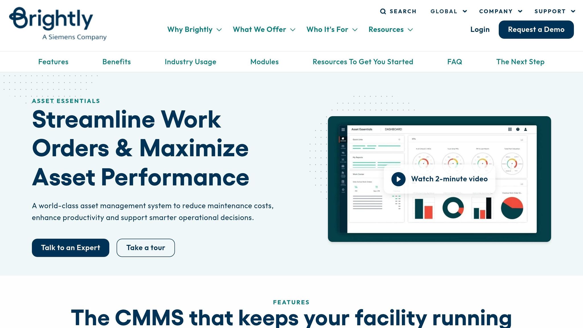
Brightly leans less toward planning-heavy infrastructure systems and more toward day-to-day facilities and grounds work. Brightly Asset Essentials is built for facilities, buildings, parks, and public works maintenance. That makes it a better fit for HVAC, municipal campuses, grounds, and utility assets than for road-and-bridge programs. If an agency needs to manage complex linear infrastructure, Brightly usually steers them to its separate Confirm product instead.
Infrastructure Coverage
The platform works well for facilities and campus-style settings. Cities use it to manage HVAC systems, building envelopes, parks, walkways, and utility assets such as water and sewer lines. One Oak Lodge Water Services District leader put it this way:
"Using Brightly, we can see the optimal location and timing of renewal projects for both water and sewer. This allows us to combine projects and greatly reduce equipment costs." - Assistant Maintenance Manager, Oak Lodge Water Services District
GIS and Field Operations
Asset Essentials connects with Esri ArcGIS, so teams can manage assets on a map and assign work orders by location. For field crews, that matters. If service drops in the field, the mobile app still works offline, which helps crews keep moving instead of waiting on a signal.
The app also supports:
- QR code and barcode scanning
- OCR data capture
- Breadcrumbs tracking to reduce drive time
In Blue Springs, Missouri, the parks team expanded Asset Essentials to manage 600 acres and six municipal buildings, moving from reactive repairs to preventive maintenance.
Maintenance and Lifecycle Planning
Preventive maintenance schedules can run automatically based on time intervals or meter readings. Smart Assets connects IoT sensors to critical equipment, while Asset Investment Planning uses condition, maintenance, and usage data to support budget requests and forecast replacements.
Government Integrations and Fit
Outside the Brightly suite, native integrations are limited. The platform syncs purchase order data with common ERP systems and includes a Connector Tool for automated data imports and exports. But built-in third-party connections are mostly limited to Microsoft Excel and other Brightly products, including Predictor, Confirm, and Assetic.
It also includes a citizen portal, which lets residents submit and track service requests in real time.
On review sites, G2 rates it 4.2/5 and SelectHub reports 86% satisfaction. Users often praise support and the work order portal, but they also point to rigid reporting and a steep setup curve.
The next platform moves farther into public works and utility asset management.
5. NEXGEN Public Works Asset Management
NEXGEN is built for public works and utilities, and it also covers facilities and fleet. That makes it a fit for agencies that need one system for roads, bridges, signs, water, sewer, stormwater, treatment plants, and municipal buildings. Its edge is pretty clear: it brings utility-focused maintenance together with GIS, mobile field work, and lifecycle planning.
Infrastructure Coverage
NEXGEN tracks a wide range of public assets, including roads, bridges, street lights, signage, water distribution, sewer/wastewater, and stormwater collection systems. For utility crews, one helpful feature is automatic migration of CCTV inspection data straight into the asset management system.
That can save time and cut down on manual entry. In the City of Livermore Water Resources Division, rolling out NEXGEN across 22 departments led to a 23% reduction in reactive maintenance tasks.
GIS and Field Operations
NEXGEN uses an Esri-based GIS model, so municipalities can manage assets on a map instead of in a static list. For field teams, that matters. Technicians can pull up GIS-mapped assets on iOS or Android devices, update work orders in real time, and get alerts when new tasks are assigned.
Users often point to the mobile app as a strong part of the platform. At the same time, some say setup can be hard at first, with a steep learning curve during implementation.
Maintenance and Lifecycle Planning
NEXGEN calculates an Asset Condition Index (ACI) for each asset, which helps teams prioritize work based on risk and estimate the chance of failure. Its NAMI AI module reviews asset data to predict risk and failure, giving staff another way to spot trouble before it turns into a bigger issue.
The platform also includes what-if scenario modeling and long-term funding forecasts. In plain terms, teams can test different spending paths and see how those choices may affect asset life and future budgets. NEXGEN says these features can extend asset life by 25% and improve operational efficiency by 20%.
Government Integrations and Fit
For cities and utilities, software rarely works alone. NEXGEN connects with SCADA systems to trigger maintenance work orders based on equipment run times, which is especially helpful in water and wastewater operations. It also offers APIs for accounting systems and 311 portals.
Deployment is flexible too. NEXGEN holds FedRAMP Moderate authorization and supports cloud, on-premise, and hybrid deployment options.
Berkeley's IT director said the platform met the city's requirements on time and on budget.
Pricing starts at $175 per user, per month. SelectHub gives NEXGEN a 71/100 rating, with 73% user satisfaction based on 17 reviews. It also earned Best-in-Class honors for Asset Management, Resource Allocation and Work Order Scheduling, and Work Order Management.
The praise isn't universal, though. Common complaints include difficult ad hoc reporting and a steep setup curve.
The next platform shifts toward broader government workflow and integration needs.
6. Catalis Infrastructure and Asset Management

Catalis is the most ERP-centered option in this group. It brings roads, sewers, fleets, equipment, signs, and municipal buildings into one database. Asset management also connects straight to finance and citizen service workflows.
Infrastructure Coverage
Catalis includes specialized modules for narrower workflows, such as weed and pest management. Field staff can track infestations and inspections in real time. On the finance side, the system supports reporting on initial cost, depreciation, and replacement cost across asset classes.
GIS and Field Operations
Catalis integrates with Esri ArcGIS Online and ArcGIS Enterprise. Its mobile app lets crews collect asset data and complete condition assessments in the field.
One useful detail: service requests can be routed automatically. When a resident submits a request, the system sends it based on geographic boundaries, districts, or the asset tied to the issue. That means the right crew gets the job without someone sorting requests by hand. If you want GIS, field work, and citizen requests working in the same place, that matters.
Maintenance and Lifecycle Planning
Catalis tracks labor, materials, inventory, and costs against each work order. For longer-range planning, it also includes forecasting tools plus ERP-based financial reporting for initial costs, depreciation, and replacement costs.
Government Integrations and Fit
Catalis connects asset management with taxation, accounts payable, payroll, and the general ledger through its ERP platform. It also ties into permitting, licensing, and 311/citizen request systems. Agencies can deploy it on-premises or in the cloud.
That ERP link is what sets Catalis apart from the more GIS-heavy or maintenance-first platforms above.
How the Six Platforms Compare Across Core Local Government Needs
The biggest gaps come down to coverage, GIS depth, and how closely each platform connects asset data with day-to-day government work. That’s the main lens to use here. The best fit isn’t just about which system can store the longest asset list. It’s about which one lines up with how an agency actually works.
Infrastructure Coverage
OpenGov covers the broadest mix of public works and utility assets. Trimble Cityworks stands out most for GIS-led utility networks. Cartegraph leans hardest into planning-first maintenance. Brightly is a better match for facilities and campuses. NEXGEN fits public works and utilities well. Catalis is geared more toward ERP-linked asset workflows.
That matters on paper. But in practice, field usability often decides whether staff use the system every day or avoid it when things get busy.
GIS and Field Operations
Cityworks is the most GIS-centered option, with ArcGIS serving as the main asset record. OpenGov uses ArcGIS too, but puts more weight on shared operations, mobile field work, and broader municipal workflows. Cartegraph, Brightly, NEXGEN, and Catalis all support mobile field work, though GIS sits closer to the center in some than others.
Once assets are mapped, the next step is simple: how does the platform turn that data into maintenance choices staff can act on?
Maintenance and Lifecycle Planning
OpenGov puts a lot of focus on preventive and condition-based maintenance, along with scenario modeling. Cartegraph is strongest for funding scenarios and long-range planning. NEXGEN adds risk scoring and predictive maintenance. Brightly leans toward routine preventive work. Cityworks balances maintenance with GIS-driven operations. Catalis connects work orders to finance.
That’s where the split starts to show. Some platforms help teams think farther ahead. Others are built more for steady execution and day-to-day work management.
Government Integrations and Fit
OpenGov fits agencies that want asset management tied closely to finance, billing, and permitting. Cityworks fits GIS-heavy organizations. Cartegraph fits planning-focused teams. Brightly fits facilities operations. NEXGEN fits utilities and public works. Catalis fits agencies that want ERP-connected workflows.
Those differences become a lot clearer when you look at each product’s strengths and weak spots.
Pros and Cons of Each Platform
No single platform comes out on top in every area. The best choice depends on your agency’s size, how far along it is with GIS, and whether the bigger need is deep capital planning or a system field crews will use day in and day out.
The table below narrows things down to each platform’s best fit and biggest drawback for local government teams.
| Platform | Key Pros | Key Cons |
|---|---|---|
| OpenGov EAM | Live Esri ArcGIS sync; part of a unified platform for ERP, billing, and CRM | High data entry discipline required; more than a small, single-department agency needs |
| Trimble Cityworks | GIS-centric, map-first architecture; strong permitting and licensing integration | Requires dedicated administration; implementation requires strong GIS coordination and data modeling |
| Cartegraph | Strong condition scoring; specialized public works inspection-to-maintenance workflows; robust asset hierarchy | Significant configuration needed to match local processes; reporting can be admin-heavy |
| Brightly | Strong for facilities, campuses, parks, and routine maintenance; native GIS supports map-based work | Less suitable for road-and-bridge programs; depends on clean historical data |
| NEXGEN | Risk and criticality modeling; FedRAMP authorized; automated FEMA reimbursement reporting | High change management barrier; requires strong organizational alignment to get full value from advanced features |
| Catalis | ERP-connected workflows link asset management directly to finance, payroll, and citizen services | Less depth in GIS-driven field operations compared to Cityworks or OpenGov |
Conclusion
The best pick comes down to how your agency works right now, not just which product has the strongest feature list. Look at three things first: GIS depth, lifecycle planning, and how closely the system needs to tie into finance and day-to-day operations.
Trimble Cityworks makes the most sense if your agency has a dedicated GIS team and wants the map to be the system, not just sit on top of it. Cartegraph works well for agencies that want predictive analytics without a GIS-heavy setup. If your main goal is linking daily maintenance work with long-range capital improvement planning and city-wide financial governance, OpenGov EAM is the strongest fit. Brightly is a good match for facilities and parks, while NEXGEN lines up well with utilities and public works. After product fit, the next thing that matters is the actual cost to get the system live.
More complex platforms usually take longer to roll out and cost more to maintain. So don’t stop at license fees. A 20-user team can spend about $15,000–$30,000+ over 3 years at the budget tier, or $50,000–$170,000+ at the enterprise level, once you include implementation, data migration, and training. Most deployments take 3 to 9 months, and enterprise GIS rollouts can stretch to 6 to 12 months. It also helps to set aside another 10%–15% of annual software spend for training and onboarding.
A simple way to lower risk is to start with one asset class, like fire hydrants, and test the workflow there first. Then ask for a live migration using your own records.
FAQs
How do I choose the right asset management software for my agency?
Prioritize software with detailed audit trails so teams can see what changed, when it changed, and who made the change. That kind of visibility helps with accountability and makes audits a lot less painful.
Start with your core needs. Some teams need GIS-focused infrastructure tracking. Others need broader asset lifecycle management across fleets, facilities, and equipment. The right choice depends on how your assets are spread out and how your team works day to day.
You’ll also want to confirm a few practical things before making a call:
- Mobile access for field teams
- Strong integration with your current systems
- Support for regulatory compliance
- Automated reporting for budget planning and audits
If those pieces aren’t in place, even a good platform can turn into a headache fast.
What does implementation usually cost, and how long does it take?
Implementation costs and timelines for local government asset management software can vary a lot. It depends on the vendor, the size of your team, and how far the project needs to go.
The software license is only part of the picture. You also need to budget for implementation, training, data migration, and integrations. Those added costs can range from $5,000 for a small organization to $120,000+ for a more complex, citywide rollout.
One step can make a big difference: finish condition assessments before you choose the software. Doing that can speed up implementation by 40%.
For budget planning, don’t rely on public pricing alone. It often leaves out a big part of total ownership costs, so it’s smart to ask vendors for formal quotes.
Should we start with one asset class or roll out city-wide?
It comes down to your agency’s bandwidth and how much central control you need. Starting with one asset class - like fleet or facility equipment - usually gets you up and running faster. It also gives staff time to get used to digital workflows, mobile inspections, and condition-based tracking without changing everything at once.
A city-wide rollout gives you instant visibility across departments such as parks, water, and public works. That makes it easier to plan capital spending, pull cross-department reports, and keep clean audit trails.
Related Blog Posts
- Top 7 AI Scenario Planning Tools 2026
- 7 Tips for Choosing Invoicing Software
- Best AI Tools for Waste Tracking
- 10 Key Features in Data Catalog Software
More on StackRundown
Continue on the Software Comparisons hub, or read next: